Thursday November 5th at 7pm, Mr. DeVoe will be presenting his 2009 Thru-hike in his classroom at Groton Middle/High School in room 302. It will also be available live at http://grotonsciencegeek.blogspot.com
Presentation
on 03 November 2009News
on 26 August 2009The Syracuse Post-Standard and Motion-X cover the Groton Appalachian Trail Project.
The Groton Appalachian Trail Project raised over $400 for Groton High School's environmental science club, "Generation - Z" and $163 for the Nature Conservancy. Thanks to everyone that donated.
What a Journey!
on 05 August 2009 After Courtney came for a weekend we said our goodbyes to Lucy and entered the homestretch of the Appalachian Trail. Maine is truly a magical place. We hiked through moss and lichen-covered forests with majestical old-growth pines. We hiked past lakes without one house on the shore and heard the eery cry of the loon on numerous occasions.
  After picking up our last mail drop in the cool little town of Monson, we entered the "100 mile wilderness". We got dropped off at the trailhead by a guy in a pickup that reminded me of the scene in "Into The Wild" when Chris gets dropped off in Alaska. The sign serves as a warning to those inadequately prepared, however, the irony here is that if you truly are carrying the weight of 10 day's worth of food to satisfy your thru-hiker appetite, there is no way you're going to make it all the way through. We did it in 4.5 days. The first half was a bit challenging and we didn't cover as many miles as we would have liked. There were a couple decent climbs and several rivers that we had to ford, the deepest being about waist-deep.
 The area wasn't as remote as I thought it would be. Over the years, logging roads have provided access for people so it is no longer essential to start at the beginning. I though we would only see other long-distance hikers but we saw many day hikers and boy scout groups. About 3/4 of the way through we got our first glimpse of Mt. Katahdin from the shore of a lake. The end looked so near, but in typical AT fashion, the trail took the circuitious route as it meandered through the woods for another 30 miles or so to the base of the mountain.
  Mt. Katahdin was like no other mountain I've ever climbed. For the first 1/3 of the way up the mountain it looked as if it were going to rain any second. People were actually coming down because they went part way up and turned around because it was windy and cloudy with no view. We kept truckin' though. Getting a picture at the end was imperative. As soon as we reached the treeline it began to clear up and eventually the sun even came out. After treeline we still had a 2 1/2 mile hike to the summit. We had great visibility at the top. They say Katahdin is a great way to finish the AT and I couldn't agree more. It is a special place with an indescribable view.
 I purposely waited a few days to write this final post about our journey because I needed a few things to sink in. We were in such a hurry to finish the trail but during the bus ride on my way home I was already missing the trail. It was sad because I was finished with the hardest but most rewarding thing of my life. I saw beautiful things that I tried so hard to share on here but they can only be experienced to give full meaning. Living homeless for 4 months is a great lesson. If everyone could live like we did for a week this would be a much stronger country. There would be less greed, more empathy, and more appreciation for nature and what we have around us. Right now I'm sitting at Collegetown Bagels in Ithaca drinking a coffee that was made with water I didn't have to filter from a muddy stream. My laptop is plugged in to free electricity and in a second I will use their flush toilet and wash my hands with warm running water. When I leave I will throw my garbage into their trash instead of sealing it up in a ziplock bag to carry with me. It's amazing!
The next step is to walk back into the classroom. I've learned that, one, this country is BIG (something you only realize when you walk it) but secondly, it is also very beautiful. The threats to that beauty are everywhere though. Invasive species are destroying our forests. Many of these threats are directly tied to us though and my pledge this year and the rest of my career is to help students make informed decisions about their actions...the importance of recycling and "voting with your dollar" to make smart purchases. Hopefully, it'll help slow down the rate at which the logging trucks take apart the forests of Northern Maine and beyond. Thanks again to everyone involved in making this project possible.
I'll end with two great quotes I came across while hiking:
“When the power of love overcomes the love of power, the world will know peace.”
-Jimi Hendrix
"Be the change you want to see in the world."
-Mahatma Gandhi
Sent from my iPhone
My GPS Position
on 29 July 2009Sent from my iPhone
Maine
on 28 July 2009
capture it but I couldn't resist this one from Mt Bigelow. This is
from the last 4000 ft mtn before Katadin. Maine is so amazing. I
realized I have about 50 waypoints of places along the AT that I want
to revisit and explore beyond. There's just not enough time - or is
life just too crudded up with other stuff?

we're looking at finishing a week from Thursday or Friday. We're just
about done with the mail drops I assembled back in March and have
enjoyed reading the quotes Mrs Filzen put in a box of granola bars -
I've definitely been at the end of my rope a few times over the past
few months. = )

and droppings in Connecticut. We finally saw one near Sabbath Pond - a
huge bull moose. What an amazing sight!

but she isn't allowed in Baxter State Park at the end. Plus we have to
ford some rivers and she hates water. If you want to say hi to this
celebrity and check out her impressive hind leg muscles she will be in
the Ithaca area for the next couple weeks.
Welcome to Maine
on 25 July 2009
slackpack us so I was on the trail at 5:45am. It was one of those days
where the only people hiking were thru-hikers. It was pouring and cold
as I left. The trail has become overgrown and extremely muddy, rocky,
and full of roots. Every time I hit a branch, a night's worth of
accumulated rainfall would fall on me. The shortest option for the
slackpack was 31 miles because there were no other road crossings -
not even a dirt forest service road. That in itself, especially with
several big climbs, is a big day. However, I also had to do Mahoosuc
Notch, the hardest mile on the whole AT in slick conditions. It wasn't
too bad with just a daypack though and it was a pretty cool area. It
was a mile between 2 cliffs where large boulders have fallen over the
last couple thousand years. I had to climb over, around, and under
these large boulders and there was even ice still in some of the
crevices. I finally got done at 9:15 and gladly took my soaked shoes
off. Today we're slackpacking another 20 miles.
Taking in the sights.
on 23 July 2009
missed! I was surprised (and glad) by the number of teenagers and
younger kids hiking in the Whites with their families or summer camps.
If you get the opportunity, make the trip one of these summers.

slackpack from Pinkham Notch to Gorham, NH. The Whites have been
challenging but amazing. The last 2 days were cloudy so there weren't
any views but we got amazing above-treeline sights earlier in the
week. In this part of the country any elevation above ~4,400 ft is
bare rock because the wind and cold make it hard for trees to live.
Most of the Whites are like this and I definitely plan on coming back
again to hike more...it's ansolutely amazing here. Tomorrow when we
hit Maine, we will only have 281 miles left!
6,288ft
on 22 July 2009
Mt Washington. This is the highest point in the Northeast and holds
the land speed wind record of some 280 miles per hour. This picture is
of the trail leading to the top. The vegetation, mostly shrubs,
grasses, and lichens, are only found on a few mountaintops in the
lower 48 and hundreds of miles north in the arctic tundra. The
weather today is cloudy, windy, and in the lower 50s. The average
summer high is 51 and and average winter high is 15.
MotionX-GPS Track: Franconia Ridge
on 21 July 2009Hello,
Mr. DeVoe uses MotionX-GPS on the iPhone 3G and is sharing with you the following track:
| Name: | Franconia Ridge |
| Date: | Jul 21, 2009 11:18 am |
| Distance: | 1.61 miles |
| Elapsed Time: | 41:32.8 |
| Avg Speed: | 2.3 mph |
| Max Speed: | 12.8 mph |
| Avg Pace: | 25' 47" per mile |
| Min Altitude: | 4,608 ft |
| Max Altitude: | 5,100 ft |
| Start Time: | 2009-07-21T15:18:41Z |
| Start Location: | |
| Latitude: | 44.149405º N |
| Longitude: | 71.644348º W |
| End Time: | 2009-07-21T16:00:14Z |
| End Location: | |
| Latitude: | 44.170199º N |
| Longitude: | 71.643171º W |
Click on this link to display the track in Google Maps. This link will be valid until Aug 20, 2009 9:29 AM PDT.
There are two files attached to this email:
"Franconia Ridge.kmz" is a Google KMZ track that can be displayed in Google Earth or Google Maps.
"Franconia Ridge.gpx" is an Open Standard track that can be displayed by select mapping software.
MotionX-GPS Commonly Asked Questions:
| Q1: | What is MotionX-GPS? |
| A1: | MotionX-GPS, available for the iPhone 3G, is the essential application for hikers, bike riders, joggers, and geocaching enthusiasts. It puts an easy-to-use, state-of-the-art handheld GPS system on your iPhone 3G. |
| Q2: | Can I use MotionX-GPS? |
| A2: | Sure! MotionX-GPS Lite for the iPhone 3G is free and can be downloaded from the iTunes App Store here. |
| Q3: | How can I display tracks in Google Earth? |
| A3: | Follow the directions on the Google Earth web site to download and install the Google Earth program. Save the attached Franconia Ridge.kmz file to your computer. Launch Google Earth, select File, Open, and open the saved Franconia Ridge.kmz file. |
| Q4: | What is a GPX Track? |
| A4: | GPX stands for GPS Exchange Format and is used to transfer GPS data between many GPS devices and applications, including Google Earth. A track is a path recorded by MotionX-GPS showing movement over the surface of the Earth. |
| Q5: | This e-mail was forwarded to me and I can't find the attachments! |
| A5: | Some e-mail programs do not include the original attachments by default when forwarding an e-mail. In this case, the sender must reattach the original files for them to be included. |
Please contact us here with any comments or questions.
All the best,
The MotionX Team
US and Foreign Patents Granted and Pending. Fullpower® is a registered trademark of Fullpower Technologies, Inc. MotionX™ is a trademark of Fullpower Technologies, Inc. © Copyright 2003 - 2009 Fullpower Technologies, Inc. All rights reserved.
ver: GPS/5.1 ver: com.fullpower.motionx.gps.web.Version@224d2f; ref-id: 6ca826d1-d123-4f5f-9099-1dc5c7e40480

probably the best view of the whole AT so far. These mountains are
though but very rewarding. They remind me a lot of the Adirondacks.
The White Mountains
on 19 July 2009
Mountains in New Hampshire where it is very remote and cell phone
service is rare. I will still post as much as possible but this is my
first good signal in a couple days. The views have been great though
and I'm looking forward to the next couple days even though this is
supposedly the hardest stretch on the whole AT. This is a porcupine
that Lucy was flirting with the other day. Luckily she didn't get any
closer.
New Hampshire
on 16 July 2009
night Kevin, Jon, Mr Giroux, Lucy and myself marched through Hanover,
NH and turned a couple heads as we hiked along the streets and
eventually retreated back into the woods to find a camp spot. Hanover
is a cool little town (home of Dartmouth College). We should be
entering the White Mountains in a day or two.
Maine Junction
on 15 July 2009
and AT split. We continued east after here and are heading toward New
Hampshire. We've been fortunate enough to slackpack for a few days now
and are covering over 20 miles a day. Mr Giroux is still here and
holding up well.
MotionX-GPS Track: The Green Mtns
on 14 July 2009Hello,
Mr. DeVoe uses MotionX-GPS on the iPhone 3G and is sharing with you the following track:
| Name: | The Green Mtns |
| Date: | Jul 12, 2009 9:23 am |
| Distance: | 7.87 miles |
| Elapsed Time: | 3:12:10 |
| Avg Speed: | 2.5 mph |
| Max Speed: | 12.5 mph |
| Avg Pace: | 24' 25" per mile |
| Min Altitude: | 1,913 ft |
| Max Altitude: | 3,411 ft |
| Start Time: | 2009-07-12T13:23:08Z |
| Start Location: | |
| Latitude: | 43.207330º N |
| Longitude: | 72.970076º W |
| End Time: | 2009-07-12T16:35:18Z |
| End Location: | |
| Latitude: | 43.289386º N |
| Longitude: | 72.938933º W |
Click on this link to display the track in Google Maps. This link will be valid until Aug 13, 2009 10:59 AM PDT.
There are two files attached to this email:
"The Green Mtns.kmz" is a Google KMZ track that can be displayed in Google Earth or Google Maps.
"The Green Mtns.gpx" is an Open Standard track that can be displayed by select mapping software.
MotionX-GPS Commonly Asked Questions:
| Q1: | What is MotionX-GPS? |
| A1: | MotionX-GPS, available for the iPhone 3G, is the essential application for hikers, bike riders, joggers, and geocaching enthusiasts. It puts an easy-to-use, state-of-the-art handheld GPS system on your iPhone 3G. |
| Q2: | Can I use MotionX-GPS? |
| A2: | Sure! MotionX-GPS Lite for the iPhone 3G is free and can be downloaded from the iTunes App Store here. |
| Q3: | How can I display tracks in Google Earth? |
| A3: | Follow the directions on the Google Earth web site to download and install the Google Earth program. Save the attached The Green Mtns.kmz file to your computer. Launch Google Earth, select File, Open, and open the saved The Green Mtns.kmz file. |
| Q4: | What is a GPX Track? |
| A4: | GPX stands for GPS Exchange Format and is used to transfer GPS data between many GPS devices and applications, including Google Earth. A track is a path recorded by MotionX-GPS showing movement over the surface of the Earth. |
| Q5: | This e-mail was forwarded to me and I can't find the attachments! |
| A5: | Some e-mail programs do not include the original attachments by default when forwarding an e-mail. In this case, the sender must reattach the original files for them to be included. |
Please contact us here with any comments or questions.
All the best,
The MotionX Team
US and Foreign Patents Granted and Pending. Fullpower® is a registered trademark of Fullpower Technologies, Inc. MotionX™ is a trademark of Fullpower Technologies, Inc. © Copyright 2003 - 2009 Fullpower Technologies, Inc. All rights reserved.
ver: GPS/5.1 ver: com.fullpower.motionx.gps.web.Version@224d2f; ref-id: 1b550e3b-534d-4bd6-8622-1aae6e1f5fa7
My GPS Position
on 13 July 2009Mr Giroux joined up with us for a couple days. Today is day 100 on the trail and we also passed the 500 miles to go line. Right now we're standing on top of Mt Killington, VTs 2nd highest peak and popular ski destination. It's incredibly windy but we have awesome views of the Adirondacks and White mountains.
Sent from my iPhone
Vermont
on 10 July 2009
distance hiking trail in the country and one of the inspirations for
the AT. The trail has gone by several beaver ponds as it follows a
ridge in the Green Mountains. The only problem with the Long Trail is
that it is very muddy, especially since it's been raining so much and
has suffered a lot of erosion because of it's heavy use by hikers.
Today we're shooting for 25 miles. We should be in Rutland, VT on
Tuesday for laundry, a shower, and a good meal.
My GPS Position
on 09 July 2009The climb here to the MA/VT screamed "welcome to the final stretch" as we climbed from 600ft to over 2000ft very quickly. We'll be at higher elevations until the end.
Sent from my iPhone
I'm aware that there is something wrong with the blog template.
However I am currently sitting on a log somewhere in northern Mass. so
I'll try to fix it if I get to a library soon. Any ideas about how to
fix it?
Sent from my iPhone

with an invasive fungus that came over from another part of the world.
It is here in Mass. also. I hiked over a couple hills that looked like
Beech graveyards. Branches were everwhere and all of the trees were
slowly dying. Our sick forests have probably had the biggest impact on
me throughout this trip - whether it's the Beech fungus, gypsy moth
larvae, Hemlock wooly adelgid, American Chestnut, etc. - our forests
are dying. Why is it that the death of an overrated pop star can
dominate the media for over a week but the death of millions of acres
of forests barely get a headline? One way you can help stop the
spread is to buy firewood near where you're camping instead of
transporting it over long distances. Better yet, go to college to
figure out a solution.
Cookies
on 08 July 2009
For years she has been providing fresh cookies to hikers and
blueberries when they're in season. This is just one of many aspects
of the trip that make hiking the AT a truly unique experience.

driven under this many times on my way too and from Boston visiting my
friends Brad and Kim. Every time I passed under I always thought
"someday I WILL be walking over this road" and here I am.
Ps. The mosquitoes are a little better.
A Test
on 06 July 2009This was almost a post to announce that I officially quit the trail.
The mosquitoes yesterday and this morning were horrendous. Between
that and the heat and humidity it's been a mental roller coaster. I
breathed in and choked on 5 mosquitoes as I climbed a 700ft ascent
this morning. Kevin and I took a long break around noon wondering what
we are doing out here. It's so hard to remain positive at times like
these. I've just had to keep reminding myself that this is my only
chance until I retire to thru-hike the AT. And on we go...
Sent from my iPhone

moment to point out a way to help Groton Central Schools. On the right
side bar is your opportunity to donate, per mile, to Groton's
environmental science club. They go on field trips and organize
projects around the school that helps make the school "green". You may
also donate to The Nature Conservency instead.
Secondly, if you are a current or former AT thru or section hiker, I
am collecting advice for the average American teenager. If you'd like
to submit something please email me or leave it as a comment and include your trail name and where you're from. Thank you!
Happy 4th of July
on 04 July 2009
in the valley below. For a country that imports most of it's oil,
nothing is quite as patriotic as guys doing circles in their own
carbon fumes. Some day we'll look back at the recreational waste of
fossil fuels as a "what were we thinking" time in our history. Few
people see that now though. What a shame.
Hello,
Mr. DeVoe uses MotionX-GPS on the iPhone 3G and is sharing with you the following track:
| Name: | Kent, CT - Rt. 4 |
| Date: | Jul 3, 2009 8:38 am |
| Distance: | 12.4 miles |
| Elapsed Time: | 4:38:16 |
| Avg Speed: | 2.7 mph |
| Max Speed: | 41.2 mph |
| Avg Pace: | 22' 18" per mile |
| Min Altitude: | 272 ft |
| Max Altitude: | 38,737 ft |
| Start Time: | 2009-07-03T12:38:57Z |
| Start Location: | |
| Latitude: | 41.738831º N |
| Longitude: | 73.463302º W |
| End Time: | 2009-07-03T17:17:13Z |
| End Location: | |
| Latitude: | 41.819185º N |
| Longitude: | 73.390812º W |
Click on this link to display the track in Google Maps. This link will be valid until Aug 3, 2009 7:13 AM PDT.
There are two files attached to this email:
"Kent, CT - Rt. 4.kmz" is a Google KML track that can be displayed in Google Earth or Google Maps.
"Kent, CT - Rt. 4.gpx" is an Open Standard track that can be displayed by select mapping software.
MotionX-GPS Commonly Asked Questions:
| Q1: | What is MotionX-GPS? |
| A1: | MotionX-GPS, available for the iPhone 3G, is the essential application for hikers, bike riders, joggers, and geocaching enthusiasts. It puts an easy-to-use, state-of-the-art handheld GPS system on your iPhone 3G. |
| Q2: | Can I use MotionX-GPS? |
| A2: | Sure! MotionX-GPS Lite for the iPhone 3G is free and can be downloaded from the iTunes App Store here. |
| Q3: | How can I display tracks in Google Earth? |
| A3: | Follow the directions on the Google Earth web site to download and install the Google Earth program. Save the attached Kent, CT - Rt. 4.kml file to your computer. Launch Google Earth, select File, Open, and open the saved Kent, CT - Rt. 4.kml file. |
| Q4: | What is a GPX Track? |
| A4: | GPX stands for GPS Exchange Format and is used to transfer GPS data between many GPS devices and applications, including Google Earth. A track is a path recorded by MotionX-GPS showing movement over the surface of the Earth. |
| Q5: | This e-mail was forwarded to me and I can't find the attachments! |
| A5: | Some e-mail programs do not include the original attachments by default when forwarding an e-mail. In this case, the sender must reattach the original files for them to be included. |
Please contact us here with any comments or questions.
All the best,
The MotionX Team
US and Foreign Patents Granted and Pending. Fullpower® is a registered trademark of Fullpower Technologies, Inc. MotionX™ is a trademark of Fullpower Technologies, Inc. © Copyright 2003 - 2009 Fullpower Technologies, Inc. All rights reserved.
ref-id: 19bbef96-3a0a-4249-9c4d-8e02fb1aa25f

It was nice seeing them after over 3 months. Courtney and Koda have
also been hiking with us for the past week and they took her back to
her car in NY on their way home. Thanks again guys!
Mail Drop
on 03 July 2009
Mrs Coffey. Thanks guys! The elementary school also sent along a
sweet shirt. With our awesome recycling and composting programs, these
shirts are an awesome fit.
My GPS Position
on 01 July 2009Sent from my iPhone


State Park. The boys cooked us a great dinner and breakfast. This
morning, we hiked about 2 miles on the AT together and had lunch on
the beach of Canopus Lake before we left to continue on North. It was
great to see some of my (former) 7th grade students again. You guys
have a solid troop and I look forward to hearing of your adventures in
the future. Thanks everyone!
Still Truckin'
on 29 June 2009
in the dark. We've had to put in big miles to make sure we join up
with the Groton Boy Scouts tonight at dinnertime. For the past 15
miles or so we've heard loud booms off in the distance and today I
figured it must be bombs and gun shots from West Point. I would
probably get sick of it if I lived around here.
Hello NY
on 27 June 2009
here in nearly 3 months so it was nice. Mr Barry, my former host
teacher from Homer, sent me a compact fishing pole that I used for the
first time today. All I caught was a small Northern Pike which was too
small to cook up.

2nd half was much better than the first. The trail was marked and
maintained much better. We hiked through some very nice parts of NJ
including a National Wildlife Refuge and a sweet boardwalk with lots
of good waterfowl to observe. Lucy enjoyed the slackpack too.
New Jersey
on 25 June 2009
take care of some things at home and he already did the NJ section in
high school. He took everything in my pack but food and water and I
"slackpacked" 41 miles to High Point State Park where Kevin and his
mom picked me up. I hiked from 5:30am until 7:15pm. My legs are like
machines right now but i definitely maxed out. It's weird to think
that I will never walk that far in one day again for the rest of my
life.
I saw 3 bears and 4 deer yesterday. After 26 miles I came across a
deli so I decided to get a sandwich and a couple Gatorades. Ok, I also
got ice cream, candy, and some chips. I walked in and pluged my phone
in on my way to the counter and waited for the owner to finish up
filling to cooler with juice. He finished and walked around to serve
me. The first thing he said was "I unplugged your phone, I can't allow
that. So what can I get you"? If I had more willpower I would have
said "nothing, I think I'm all set" and walked out. In
hindsight I should have offered him the 3 cents to charge my phone for
a half hour just for the entertainment of his reply. The funny thing
is that at the beginning of the trip I used to ask people if they
minded if I plugged in my phone while I ate at a diner or deli but I
usually got a look like "of course you can, why bother asking"?
Anyway, this was my first experience ever with someone in NJ. I've
only driven through the state. Right now I'm staying at Kevin's
parents house - where people are a little more human. They're great
people and have a cool post/beam house in a really nice part of the
state. We're taking a "zero" day and my feet appreciate it after
yesterday. Tomorrow we're shooting to finish the state and enter good
ol' New York.
Food and Family
on 23 June 2009
and took us out to dinner. It was nice seeing her again and food other
than granola bars and honey buns is always a special treat.
Someone mentioned I should try out for a Geico caveman commercial.
Yesterday we got a ride to a store from an elementary teacher down
here and he seemed VERY surprised when I told him I was a teacher as
well. What?? Teachers in PA don't look like this?? So tomorrow we
enter state #8, New Jersey. Have a great summer Groton students and
make sure you check the blog all summer!
My GPS Position
on 22 June 2009This is a pretty crazy area. We are outside of Palmerton, PA which was home to a century of zinc mining and smelting. This practice severly affected the area as emmisions created very acidic soils and removed a lot of the mountain vegetation. The federal governent shut down the zinc furnaces in 1980 and put it on the Superfund cleanup list in 1982. The area is slowly coming back to life thanks to the application of Ecoloam -a mixture of municipal waste sludge, fly ash, lime, fertilizer, and seeds. Pines, tall grasses, and blueberries have taken hold as the wounds heal. There are still plenty of sandstone and quartzite boulders as well.
Before you begin cursing the zinc industry though we should consider all of the products that contain zinc. It's just a shame it was processed so irresponsibly.
Sent from my iPhone

Needless to say I am getting my fix of antioxidants!
Right now it's 5:55am and we just woke up for a big day. We've been
putting in around 20 miles a day but we're shooting for 25 today.
We're outside of Allentown, PA right now and it seems the further east
we get in this state, the rockier it gets. Our feet are pretty sore
from walking on sharp pointed rocks. Today we'll go through
Palmerton, PA which supposedly has the toughest rock scramble south of
New Hampshire so that'll take some time. Tomorrow evening we''ll be
entering the 8th state, New Jersey.
Sent from my iPhone
Snakes
on 20 June 2009
sighting these things. He described the snake as "not very long but
very thick". It was coiled up and it rattled as he got closer. The
rattle was like "the sound of Tic-Tacs being shaken". Honestly, I'm ok
if I don't see one.
My GPS Position
on 17 June 2009This is Stony Mtn. I can hear hammering from the coal mine on the other side of the mountain. Is it visable on Google Earth?
Sent from my iPhone

wait for Mr DeVoe and Kevin to catch up. I just remembered that school
is almost out for summer so I wanted to say a few things.
First of all, I hope you all had a great but challenging school year.
Make sure you keep your brain busy this summer by reading a couple
books. I know I will be.
Secondly, try to get outside as much as possible. I know a lot of you
play soccer or baseball over the summer but there are all sorts of
other ways to stay busy outside. I've learned from this trip that life
is all about your experiences and things you learn not about what
video games you own or stuff like that. In the Shenandoah Mtns, my
favorite moment was standing on Stoney Man cliff after a thunderstorm
cleared up. It created the most beautiful sunset I've ever seen. That
experience could never be reproduced on a TV screen.
Get outside and be safe this summer Groton.
-Skoob

dangerous road crossing. The fact that this trail extends non-stop
through the Eastern US is truly amazing. Thousands of people have
spent thousands of hours building and maintaining this 2,175 mile long
trail. Funding for projects like this tunnel come from Appalachian
Trail Conservancy memberships, donations, and grants.
1/2 way
on 15 June 2009
eat anything and still lose weight. I try to eat healthy but calories
and fat are actually very necessary when you hike 10 hrs a day.
It's tradition that at the 1/2 way point hikers take the "1/2 gallon
challenge". I finished mine easily in under 20 minutes but I don't
think I'd ever do it again. It totalled 1600 calories.
I chose Peanut Butter Mania in honor of my girlfriend Courtney because
I think that's what she would have picked out of the selection. As you
can imagine it takes a lot of work for someone to disapear into the
wood for 5 months. Not only has she been finishing up a great 1st year
of teaching at Caroline Elementary in Ithaca but she has also been
filling a critical role of mailing us food drops, taking care of the
pets, mowing the lawn, taking care of my mail, etc. I'm 1/2 way done
and enjoying everything but really looking forward to getting home to
her and back to the "normal" life.
Dear Groton 7th graders,
I hope you enjoyed this year and getting the opportunity to learn from Mr Rafferty in science as well. I heard he's been doing a great job. The first day of school I said that this would be a year of transition and great personal accomplishments. I enjoyed seeing many of you succeed in a variety of ways this year but I am sorry I missed out on spring sports, the drama club production, and the spring awards picnic. Even though I missed these things I look forward to seeing your accomplishments in the years to come. Even though you change teachers each year, you should know that we all keep an eye on you as you progress through school and after. Right now I am seeing the 9th and 10th graders (my first group) become leaders in the high school and the community.
Today marks the 1/2 way point on the Appalachian Trail. Most hikers that start in Georgia never make it this far due to injury or the monotony of doing the same thing every day. I feel lucky because I haven't really gotten bored of the woods yet. I think it is, in part, because I went into this with some knowledge of the woods already. When most see trees, I see oaks, maples, and hickories. When most hear birds, I hear thrushes, owls, and sparrows. When most see the same things over and over, I try to look at them differently. My point is that the more you learn about things in life, the more you can appreciate and admire the diversity of things around you. Just because it is summer doesn't mean you should sit around and I hope you do not realize one August morning that you've already wasted a month of break. Get out and learn something new, explore the waterfalls of the area, or develop a new talent. I think you'll find that others will admire you for this. So today, since I will be eating a 1/2 gallon of ice cream to celebrate the 1/2 way point I wanted to leave you a gift as well. Enjoy.
Cheers,
Mr. DeVoe
A day off
on 13 June 2009
from the trail. They also brought amazing support from Groton
teachers, administrators, and students. This school and community
truly is amazing. Thank you everyone. Today we toured Gettysburg with
the best tour guide I could think of; Groton's very own, Mr Filzen
with his enthusiastic and intense delivery. The students are lucky to
have such a great history department. Mr Wiech also answered my
Appalachian Mountain geology questions. I think the science department
is pretty solid as well = ) It was a great day of relaxation and
learning. The history aspect of this trip has been most personally
rewarding to me. It is definitely something that needs to be
experienced. Tomorrow we'll say our goodbyes and they'll drop us off
to start our 18 mile day to the official 1/2 way point on the AT. I'm
looking forward to coming home but also look forward to each day of
hiking in the amazing country.
Hi Mr D.'s class. Thanks for posting. I always enjoy hearing what you
guys are up to. It sounds like you had a good time at the MOST. I went
to college in Syracuse so I've been there a couple times. It's a great
place and the IMAX is killer! Have fun at SeaBeaze for those going.
I've never been there but have heard good things. The trail is great
but it's starting to get rocky so we need to be careful not to roll an
ankle. Someone asked a question about the AT. I've heard that around
2000 people attempt to thru-hike it each year (like us). Most do not
make it. There are, however, thousands of others that do day hikes or
section hikes each year. It's a really popular trail. It's still fun
and I don't plan on giving up until I reach Maine this August! Enjoy
your weekend everyone.
Sent from my iPhone
We're about to enter the 7th state as we cross the Mason-Dixon line into Pennsylvania. Maryland was a nice hike and full of history.
Sent from my iPhone
Harpers Ferry
on 10 June 2009
all hikers stop here in Harpers Ferry to register and get their photos
taken. We were hikers number 287 and 288 for 2009.
My GPS Position
on 09 June 2009What a cool town. OK Groton, who can tell me the historical significance of Harpers Ferry?
Sent from my iPhone

Virginia again though before Harpers Ferry. The next 3 states will go
fairly quickly.
We've been adjusting to the transition into summer. Today and
yesterday are in the upper 80s and the insects are swarming our heads.
It's been rough but it's all part of it.
Coal
on 07 June 2009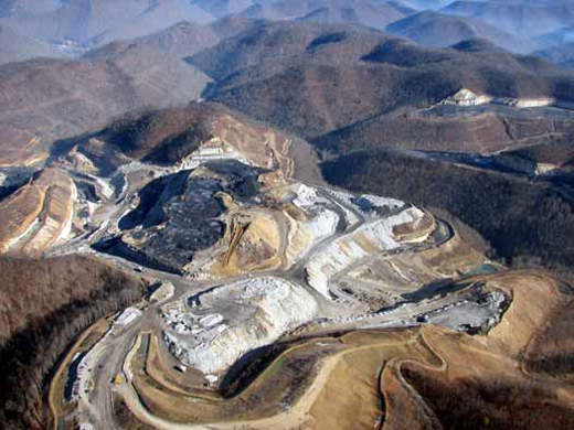 Coal mining is a huge part of the Appalachian economy. Coal is a "fossil fuel" which is the accumulation of ancient plants that died 540-240 millions of years ago in "coal swamps". It's so abundant down here that a geologic period was named the "Pennsylvanian" to reflect this. This point in Earth's history was dominated by ferns and gymnosperms with many winged insects and amphibians as the dominate land creatures. This was much earlier than the age of dinosaurs.
In the early 1900's, the burning of these "fossil fuels" became routine in our lives as we heated our homes and filled up our cars with this "stored sunlight". The sun is the ultimate source of energy on the planet and fossil fuels represent a very concentrated form of sunlight that gives off enormous amounts of energy when lit. Think about how easy it is to light your stove, ignite a lighter, turn on your car, and start your furnace.
Sadly we import a large amount of fossil fuels from the middle east in the form of oil to do the above activities. Many suggest we should be relying more on our country's abundance of coal. Coal, however, pollutes the air more than other fossil fuels. In addition, it it common practice down here to extract it from the Earth through "Mountain-Top Removal". This is where companies go into the mountains and dig through a whole mountain to clear out the coal like in the picture above. This is an ugly process that puts pollution into streams an is an eyesore from above. There is a movement to ban this practice but we need more public support. These companies are careful not to do it where people can see it (next to highways or close to where people live). If you'd like to voice your concern about this please visit this website to help and learn more. Click here for a Google Earth tour of mountaintop removal.
Instead of fossil fuels, let's Go Green! I'm interested to hear about what you all know about "alternative" forms of energy. How can we create electricity without causing pollution? Please leave a comment.
Hello,
Mr. DeVoe uses MotionX-GPS on the iPhone 3G and is sharing with you the following track:
| Name: | Va 522 - I-66 |
| Date: | Jun 7, 2009 11:33 am |
| Distance: | 7.88 miles |
| Elapsed Time: | 2:53:46 |
| Avg Speed: | 2.7 mph |
| Max Speed: | 7.6 mph |
| Avg Pace: | 22' 03" per mile |
| Min Altitude: | 733 ft |
| Max Altitude: | 1,858 ft |
| Start Time: | 2009-06-07T15:33:35Z |
| Start Location: | |
| Latitude: | 38.878298º N |
| Longitude: | 78.150859º W |
| End Time: | 2009-06-07T18:27:21Z |
| End Location: | |
| Latitude: | 38.909208º N |
| Longitude: | 78.053372º W |
Click on this link to display the track in Google Maps. This link will be valid until Jul 7, 2009 12:23 PM PDT.
There are two files attached to this email:
"Va 522 - I-66.kmz" is a Google KML track that can be displayed in Google Earth or Google Maps.
"Va 522 - I-66.gpx" is an Open Standard track that can be displayed by select mapping software.
MotionX-GPS Commonly Asked Questions:
| Q1: | What is MotionX-GPS? |
| A1: | MotionX-GPS, available for the iPhone 3G, is the essential application for hikers, bike riders, joggers, and geocaching enthusiasts. It puts an easy-to-use, state-of-the-art handheld GPS system on your iPhone 3G. |
| Q2: | Can I use MotionX-GPS? |
| A2: | Sure! MotionX-GPS Lite for the iPhone 3G is free and can be downloaded from the iTunes App Store here. |
| Q3: | How can I display tracks in Google Earth? |
| A3: | Follow the directions on the Google Earth web site to download and install the Google Earth program. Save the attached Va 522 - I-66.kml file to your computer. Launch Google Earth, select File, Open, and open the saved Va 522 - I-66.kml file. |
| Q4: | What is a GPX Track? |
| A4: | GPX stands for GPS Exchange Format and is used to transfer GPS data between many GPS devices and applications, including Google Earth. A track is a path recorded by MotionX-GPS showing movement over the surface of the Earth. |
| Q5: | This e-mail was forwarded to me and I can't find the attachments! |
| A5: | Some e-mail programs do not include the original attachments by default when forwarding an e-mail. In this case, the sender must reattach the original files for them to be included. |
Please contact us here with any comments or questions.
All the best,
The MotionX Team
US and Foreign Patents Granted and Pending. Fullpower® is a registered trademark of Fullpower Technologies, Inc. MotionX™ is a trademark of Fullpower Technologies, Inc. © Copyright 2003 - 2009 Fullpower Technologies, Inc. All rights reserved.
ref-id: 349cec3f-7196-4973-b07d-06f0b3ee0017
Diet and Exercize
on 06 June 2009
AT weight loss plan. All you do is consume 5000-6000 calories a day
in any form you want. I usually eat a mixture of Little Debbie snacks,
protein bars, and try for one all you can eat buffet a week. Sound too
good to be true? Well it's not, as long as you carry a 35 lb pack 15
- 20 miles a day!
Wildlife
on 05 June 2009
and as we got closer we saw that she had her 3 cubs with her. They
were climbing a tree as we walked by. We definitely got lucky! Today
we'll be leaving the park and hopefully get better weather soon.
It's business time
on 04 June 2009
It's a good question actually. This is a picture of a privy that every
shelter has. They are much like the outhouses that houses used to have
before indoor plumbing. If you're lucky, they even have doors!
Because the human intestines have millions of bacteria to digest food
it is very important that human waste is burried at least 150ft from a
water source so things like E.coli aren't consumed by people drinking
the water. This is part of the "leave no trace" ethics that the Groton
boy scouts are learning about. So what do you think? Do you
appreciate you bathroom at home now?

and the closest national park to Groton. It's definitely worth the trip.
Today we got another package from Groton Elementary. Thanks so much
guys! I loved reading the morning announcements scripts too. We also
received a package from the 2 airline pilots I met on the approach
trail back on Springer Mtn in Georgia. Everyone has been amazingly
supportive. Thank you all.
Feet
on 02 June 2009
way point on the AT. For the past 4 days we've done over 20 miles a
day. The terrain is a lot easier but the feet still get tender by the
end of the day. Yesterday we were on the trail at 8am and hiked until
sunset. My feet are in good shape but my baby toenails are ready to
fall off. They've been dead since week 2.
Shenandoah National Park
on 01 June 2009 We are now hiking through our second National Park. Shenandoah National Park includes 300 square miles of the Blue Ridge Mountains in the southern Appalachians with tens of thousands of living creatures including white tail deer, black bear and 36 fish species that live within the park’s streams. The Appalachian Trail covers around 75 miles within the slender park that runs North-South through Northern Virginia.
Video of the Trail
on 31 May 2009Crossing Brown Mountain Creek
Sent from my iPhone

Waynesboro, VA. This town lies at Rockfish Gap. A break in the
mountains that was important for transportation years ago before cars
and highways. Later today we will also be starting the southern end
of Shenandoah National Park.
Everything is going well though and we are still having fun. We are
now about 150 miles from the next state line and we're looking forward
to it because we're sort of growing tired of Virginia and looking
forward to seeing progress.
Trees
on 29 May 2009
means that it has never been logged for wood products. Around 99% of
US forests have been logged at some point so these areas are rare.
Next to Kevin is one of the largest American Beech trees I've ever
seen. It probably had a diameter around 5 feet. Can anyone find a
list of tree records in NYS? There is a Cottonwood tree in downtown
Moravia that is huge! I wonder how close that is to the record?
Hello,
Mr. DeVoe uses MotionX-GPS on the iPhone 3G and is sharing with you the following track:
| Name: | USFS38 - US60 |
| Date: | May 28, 2009 1:38 pm |
| Distance: | 4.12 miles |
| Elapsed Time: | 1:43:09 |
| Avg Speed: | 2.4 mph |
| Max Speed: | 14.9 mph |
| Avg Pace: | 25' 02" per mile |
| Min Altitude: | 1,121 ft |
| Max Altitude: | 1,974 ft |
| Start Time: | 2009-05-28T17:38:32Z |
| Start Location: | |
| Latitude: | 37.685444º N |
| Longitude: | 79.271185º W |
| End Time: | 2009-05-28T19:21:42Z |
| End Location: | |
| Latitude: | 37.723385º N |
| Longitude: | 79.249932º W |
Click on this link to display the track in Google Maps. This link will be valid until Jun 28, 2009 6:32 AM PDT.
There are two files attached to this email:
"USFS38 - US60.kmz" is a Google KML track that can be displayed in Google Earth or Google Maps.
"USFS38 - US60.gpx" is an Open Standard track that can be displayed by select mapping software.
MotionX-GPS Commonly Asked Questions:
| Q1: | What is MotionX-GPS? |
| A1: | MotionX-GPS, available for the iPhone 3G, is the essential application for hikers, bike riders, joggers, and geocaching enthusiasts. It puts an easy-to-use, state-of-the-art handheld GPS system on your iPhone 3G. |
| Q2: | Can I use MotionX-GPS? |
| A2: | Sure! MotionX-GPS Lite for the iPhone 3G is free and can be downloaded from the iTunes App Store here. |
| Q3: | How can I display tracks in Google Earth? |
| A3: | Follow the directions on the Google Earth web site to download and install the Google Earth program. Save the attached USFS38 - US60.kml file to your computer. Launch Google Earth, select File, Open, and open the saved USFS38 - US60.kml file. |
| Q4: | What is a GPX Track? |
| A4: | GPX stands for GPS Exchange Format and is used to transfer GPS data between many GPS devices and applications, including Google Earth. A track is a path recorded by MotionX-GPS showing movement over the surface of the Earth. |
| Q5: | This e-mail was forwarded to me and I can't find the attachments! |
| A5: | Some e-mail programs do not include the original attachments by default when forwarding an e-mail. In this case, the sender must reattach the original files for them to be included. |
Please contact us here with any comments or questions.
All the best,
The MotionX Team
US and Foreign Patents Granted and Pending. Fullpower® is a registered trademark of Fullpower Technologies, Inc. MotionX™ is a trademark of Fullpower Technologies, Inc. © Copyright 2003 - 2009 Fullpower Technologies, Inc. All rights reserved.
ref-id: 64afd3ba-1ec2-4450-a0bf-66fdac36b75b
Virginia (still)
on 27 May 2009


Subscribe to:
Comments (Atom)