Crossing Brown Mountain Creek
Video of the Trail
on 31 May 2009Sent from my iPhone

Waynesboro, VA. This town lies at Rockfish Gap. A break in the
mountains that was important for transportation years ago before cars
and highways. Later today we will also be starting the southern end
of Shenandoah National Park.
Everything is going well though and we are still having fun. We are
now about 150 miles from the next state line and we're looking forward
to it because we're sort of growing tired of Virginia and looking
forward to seeing progress.
Trees
on 29 May 2009
means that it has never been logged for wood products. Around 99% of
US forests have been logged at some point so these areas are rare.
Next to Kevin is one of the largest American Beech trees I've ever
seen. It probably had a diameter around 5 feet. Can anyone find a
list of tree records in NYS? There is a Cottonwood tree in downtown
Moravia that is huge! I wonder how close that is to the record?
Hello,
Mr. DeVoe uses MotionX-GPS on the iPhone 3G and is sharing with you the following track:
| Name: | USFS38 - US60 |
| Date: | May 28, 2009 1:38 pm |
| Distance: | 4.12 miles |
| Elapsed Time: | 1:43:09 |
| Avg Speed: | 2.4 mph |
| Max Speed: | 14.9 mph |
| Avg Pace: | 25' 02" per mile |
| Min Altitude: | 1,121 ft |
| Max Altitude: | 1,974 ft |
| Start Time: | 2009-05-28T17:38:32Z |
| Start Location: | |
| Latitude: | 37.685444º N |
| Longitude: | 79.271185º W |
| End Time: | 2009-05-28T19:21:42Z |
| End Location: | |
| Latitude: | 37.723385º N |
| Longitude: | 79.249932º W |
Click on this link to display the track in Google Maps. This link will be valid until Jun 28, 2009 6:32 AM PDT.
There are two files attached to this email:
"USFS38 - US60.kmz" is a Google KML track that can be displayed in Google Earth or Google Maps.
"USFS38 - US60.gpx" is an Open Standard track that can be displayed by select mapping software.
MotionX-GPS Commonly Asked Questions:
| Q1: | What is MotionX-GPS? |
| A1: | MotionX-GPS, available for the iPhone 3G, is the essential application for hikers, bike riders, joggers, and geocaching enthusiasts. It puts an easy-to-use, state-of-the-art handheld GPS system on your iPhone 3G. |
| Q2: | Can I use MotionX-GPS? |
| A2: | Sure! MotionX-GPS Lite for the iPhone 3G is free and can be downloaded from the iTunes App Store here. |
| Q3: | How can I display tracks in Google Earth? |
| A3: | Follow the directions on the Google Earth web site to download and install the Google Earth program. Save the attached USFS38 - US60.kml file to your computer. Launch Google Earth, select File, Open, and open the saved USFS38 - US60.kml file. |
| Q4: | What is a GPX Track? |
| A4: | GPX stands for GPS Exchange Format and is used to transfer GPS data between many GPS devices and applications, including Google Earth. A track is a path recorded by MotionX-GPS showing movement over the surface of the Earth. |
| Q5: | This e-mail was forwarded to me and I can't find the attachments! |
| A5: | Some e-mail programs do not include the original attachments by default when forwarding an e-mail. In this case, the sender must reattach the original files for them to be included. |
Please contact us here with any comments or questions.
All the best,
The MotionX Team
US and Foreign Patents Granted and Pending. Fullpower® is a registered trademark of Fullpower Technologies, Inc. MotionX™ is a trademark of Fullpower Technologies, Inc. © Copyright 2003 - 2009 Fullpower Technologies, Inc. All rights reserved.
ref-id: 64afd3ba-1ec2-4450-a0bf-66fdac36b75b
Virginia (still)
on 27 May 2009


Trail Magic
on 26 May 2009
for about 45 years. He always makes a point in being a part of all of
the positive activities at school whether it be the musical, sporting
events, prom, etc. When he heard about this trip he wrote to CutCo
Knife Company to ask if they'd be willing to donate a knife for the
trip. They did, along with a custom engraving. I've used it quite a
bit but most recently was for some trail magic we received yesterday.
We stumbled upon a bag hanging from a tree with a whole pineapple and
drinks. Thanks Mr Gambitta and CutCo.
My GPS Position
on 25 May 2009Sent from my iPhone

Along the trail we will have several friends and family join up with us to hike for a little bit. The Groton Boy Scout Troop will be joing up soon! Yesterday, Ms. Coffey, 4th grade teacher at Caroline Elementary in Ithaca joined us on the trail for a week. She is much more elaborative than myself so go on over and check out her documentation of the AT through her classroom blog.
McAfee's Knob
on 23 May 2009
people make day trips in the 3 miles from the parking lot. It has, in
my opinion, one of the best views I've seen.

VA. Later today we'll be at the exact 1/3 mark of the AT.
Big Day
on 22 May 2009
next care package in time from the post office from his parents (thank
you). It was a big day. I hiked 32 miles in 24 hrs and managed to see
some pretty cool things. This picture is of the Keffer Oak, the second
largest oak on the AT. The largest being in New York. This White Oak
is estimated to be over 300 years old and is 18 1/2 feet in girth. I
put my pack next to it to give you an idea of how big this thing was.
I also hiked along a major continental divide. Rain falling on the
left of the ridge eventually empties into the Gulf of Mexico and water
falling on the eastern side goes to the Atlantic. Tomorrow we hit
McAfee's knob, a pretty famout landmark. I'll have pictures up as soon
as possible.
My GPS Position
on 21 May 2009Should be in Catawba, VA tomorrow afternoon.
Sent from my iPhone
Sunsets
on 20 May 2009
camped under a big oak tree on top of a grassy hill overlooking West
Virginia. It was a great spot. At 7:55 we watched the NASA rocket
launch at our east and then turned around 180 degrees for a wicked
sunset.
"So throw those curtains wide. One day like this a year'd see me right."
-Elbow
MotionX GPS Track: Rice Field - Symms Gap
on 19 May 2009Hello,
Mr. DeVoe uses MotionX-GPS on the iPhone 3G and is sharing with you the following track:
| Name: | Rice Field - Symms Gap |
| Date: | May 19, 2009 2:54 pm |
| Distance: | 4.84 miles |
| Elapsed Time: | 1:35:28 |
| Avg Speed: | 3.0 mph |
| Max Speed: | 8.8 mph |
| Avg Pace: | 19' 44" per mile |
| Min Altitude: | 3,199 ft |
| Max Altitude: | 3,417 ft |
| Start Time: | 2009-05-19T18:54:36Z |
| Start Location: | |
| Latitude: | 37.375896º N |
| Longitude: | 80.757494º W |
| End Time: | 2009-05-19T20:30:05Z |
| End Location: | |
| Latitude: | 37.404461º N |
| Longitude: | 80.685450º W |
Click on this link to display the track in Google Maps. This link will be valid until Jun 18, 2009 1:40 PM PDT.
There are two files attached to this email:
"Rice Field - Symms Gap.kmz" is a Google KML track that can be displayed in Google Earth or Google Maps.
"Rice Field - Symms Gap.gpx" is an Open Standard track that can be displayed by select mapping software.
MotionX-GPS Commonly Asked Questions:
| Q1: | What is MotionX-GPS? |
| A1: | MotionX-GPS, available for the iPhone 3G, is the essential application for hikers, bike riders, joggers, and geocaching enthusiasts. It puts an easy-to-use, state-of-the-art handheld GPS system on your iPhone 3G. |
| Q2: | Can I use MotionX-GPS? |
| A2: | Sure! MotionX-GPS Lite for the iPhone 3G is free and can be downloaded from the iTunes App Store here. |
| Q3: | How can I display tracks in Google Earth? |
| A3: | Follow the directions on the Google Earth web site to download and install the Google Earth program. Save the attached Rice Field - Symms Gap.kml file to your computer. Launch Google Earth, select File, Open, and open the saved Rice Field - Symms Gap.kml file. |
| Q4: | What is a GPX Track? |
| A4: | GPX stands for GPS Exchange Format and is used to transfer GPS data between many GPS devices and applications, including Google Earth. A track is a path recorded by MotionX-GPS showing movement over the surface of the Earth. |
| Q5: | This e-mail was forwarded to me and I can't find the attachments! |
| A5: | Some e-mail programs do not include the original attachments by default when forwarding an e-mail. In this case, the sender must reattach the original files for them to be included. |
Please contact us here with any comments or questions.
All the best,
The MotionX Team
US and Foreign Patents Granted and Pending. Fullpower® is a registered trademark of Fullpower Technologies, Inc. MotionX™ is a trademark of Fullpower Technologies, Inc. © Copyright 2003 - 2009 Fullpower Technologies, Inc. All rights reserved.
ref-id: bad40025-b083-4f3d-91d1-25c26a82b8af
Hi everyone. Tonight is the annual Art Show/Italian Dinner in the high
school cafeteria. All proceeds benefit the high school outing club
that Mr Wiech runs. So if you're in the mood for great food and want
to help get Groton students into the outdoors, swing on over. The art
show is very impressive as well.
Sent from my iPhone
Greetings from Pearisburg, VA
on 18 May 2009
(near Roanoke on the WV border). Thank you Groton Elementary for
sending ANOTHER great care package and inspirational quotes. It was
also nice to read the letters from Mr D'Antonio's and Mr Goodwin's
students. Casper, Kailea, Julie, Jacob and Andrew, I haven't seen any
hillbillies but I've run into a few people that butchered the English
language pretty badly. Ben, Justyn, Colton, and Mike, I haven't had
to use the pepper spray and hopefully won't. Emily, Taryn, Kailea, Nathan, Brooke, and Sam, the announcements look good! Alyssa, the bugs haven't
been bad yet. Sam - I'm not going to quit! :-) Emma, I love Lime
Hollow too and be sure to go back this summer. Cady, the map sounds
cool. Phyllis, I'll keep my eyes open for a turtle. Deni and Tess,
it is very exciting going to all of these different places. It has
all been very memorable. Tristan, Emmilie, Lynsey, Karlee, Claudia,
Jake, Arrion, Emily, Marissa, Valerie and Emma, thanks for the good
luck and best wishes. Mike and Brittany - a time capsul - great idea!
Tyler and Marcus, sorry to hear someone disrespected your nature trail. You're
great people for cleaning it up. Thanks again and I hope I didn't
miss anyone.

but I have been so busy. Ever since we got so close to that controlled
forest fire I've wanted to learn more about them so I've been spending
time in the libraries in the towns we pass through. I bet Ms Prentiss
has some good books on the subject too. I've also been reading a very
funny book called No Talking by Andrew Clements. It's about a contest
between boys and girls to see how long they can go without talking to
one another. I've been reading that during rainy days when I hide deep
in Lucy's pack.
Virginia has been beautiful though. This is me taking a rest on the
bridge while everyone else was busy looking at the map. Streams like
this make me wish I had my fishing pole. Did you hear about the wild
ponies? They were great. They came right up close to us...a little
too close to Lucy. She didn't like them and tried biting one that got
really close. Well I hope everyone is well. If you've been reading a
good book please pass along the title and author so I can check it out.
Your friend,
Skoob

50 miles the heels have really been digging into my feet. This picture
hurt a lot more than it looks. I even hiked a day in my Crocs to help
them heal up. I was hoping to go through only 3 pairs of shoes for
this trip and it looks like I'm on schedule.
Pastures
on 15 May 2009
and dry out some clothes. Thanks for all of the birthday wishes the
other day. It was a beautiful spring day in Virginia - I couldn't ask
for a better day. This picture was taken after we hiked through a cow
pasture that day. Kevin is hoisting Lucy over a stile which we have
to climb periodically over barbed wire fences. Our next town will be
Pearisburg, VA.
My GPS Position
on 14 May 20094,400 ft in VA
Sent from my iPhone
Scenery
on 13 May 2009
next to the tree is Kevin.
Sent from my iPhone

I'm bummed I can't make it. Make sure someone Tweets some photos! So
in the spirit of science, here is a question for the high schoolers:
While hiking, everyone must treat their drinking water in some way to
remove hazardous bacteria, viruses, and protozoans. I'm oldschool and
choose to filter my water with a hand pump. This removed everything
over 5 microns in diameter. Others use iodine tablets or chlorine
drops because they are lighter than the pump.
So I ran into a guy that does this: he adds 5 drops of chlorox bleach
to a liter of water, waits a couple minutes and then add 5 drops of
hydrogen peroxide. He claims that when combined it reacts and forms
water and salt, thus being healthier than the bleach alone. What do
you think?
Salamanders
on 12 May 2009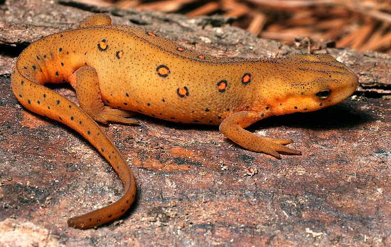 The Appalachian Mountains are home to many salamander species. Most spend part of their life on land and retreat to shallow pools to lay eggs in the spring. I've seen several that are highlighted on the previous website but my favorite is probably the red-spotted newt (Notophthalmus viridescens viridescens) These guys are found in New York State as well. I've seen them around Groton too.
  One that I'm really trying to spot is the giant Hellbender (Cryptobranchus alleganiensis). These fully-aquatic beasts can grow up to 2 feet in length. They're sort of gross looking though, don't you think? I'd love to hear about salamanders that people have seen around Groton.

It's been a 50/50 mix of forests and pasture. At the Mt Rogers/Grayson
Highlands area we encountered around 30 wild ponies. They walked right
up to us and one started licking my hiking pole handles to taste the
salt. Today we go into Sugar Grove to pick up Kevins resupply package
and get lunch. Hope all is well back home.
My GPS Position
on 10 May 2009Sent from my iPhone


Thursday night around 7:30 pm, after 18 miles, we got to a shelter just in time to dodge a passing thunderstorm. We were both still pretty energized afterward and decided to keep moving. Just before sunset the sky began to clear up. I'm trying to search my stunted vocabulary for an adjective to describe next 30 minutes; some of the most memorable minutes of my life. It was about 2 parts ethereal and 1 part outlandish, with a pinch of haunting. We began walking along a ridgetop watching the sun set and the lights begin to turn on in the small city below. We hiked as the sky turned darker and witnessed the woodland creatures competing in crepuscular chorus. We hiked through a hemlock forest in the haze that felt like some sort of scene from Lord of the Rings, full of dampness and mystery. Within minutes, the full moon came out from under a few clouds. We extinguished our headlamps to see the moonlight melt over the canopy of the May Apple monoculture like white wax.
At 3am we could hike no more, so we pitched the tent and got a few hours of sleep before descending into Damascus, VA the next morning. We had hiked 32 miles in one day.
My GPS Position
on 07 May 2009Sent from my iPhone

Sigur ros is truly surreal. Today we got an early start at 7am because
we are doing 19 miles today to double springs shelter. Another 18
miles tomorrow will bring us into Damascus, VA tomorrow evening.
History
on 06 May 2009
beautiful valley. It was featured as a backdrop in the movie, Winter
People. This barn fell on the path of the Overmountain Men. During
the Revolutionary War, 3 militias from Virginia, North Carolina, and
what is now Tennessee joined forces. 1000 men strong, they marched
south to defeat the Brittish is a bloody but critical battle in the
war. Now, the sign said the year 1780. How could that be right?

great surprise. We were expecting a package from Groton Elementary.
Thank you guys so much! I must add that you made excellent choices;
lots of stuff high in calories and protein - everything a hiker needs.
Also, special thanks to Mrs Rilley for the awesome dinners and Mr.
D'Antonio for working out the logistics.
We also received a nice box of snacks from Mrs Hunter and high school
student council. Thank you so much! You read our minds. The biggest
surprise, however, was a box of chocolates from Mr Filzen's friend who
runs a very classy candy store called The Alps in the Hudson Valley.
Thanks Terry. We appreciate the effort you put in to send those.
Thanks everyone, things like this make me feel connected to Groton and
New York.


Hi Everyone,
I wanted to take a couple seconds to answer some of the questions that have popped up. First off, I feel great. My legs no longer hurt because I have developed my "trail legs". Now I just have to make sure I don't roll an ankle or slip on a wet log or something that could put an end to the hike. The mental aspects of the trip are going to be the toughest now.
My feet are alright. I still have a couple blisters which I am not popping. I'm going to let them heal on their own. I try to keep my feet as dry as possible which has been hard lately because of the rain. I'm a little concerned with my two baby toenails. They seem discolored and maybe dead (I think my shoes are a 1/2 size too small). I'll be getting new shoes in about 300 miles though.
Lucy and Skoob are doing great. Skoob has been hiding from the rain. He sleeps in a pocket at the end of the tent. He has been great at keeping my pack organized and loves riding in Lucy's pack.
It's been great hearing from all of the elementary classes. Be sure to check the Fire post. Stephanie Johnson from the US Forest Service posted a response to your comments.
All in all, we are having fun. I'm looking forward to Virginia because the hiking is flatter. We just got done climbing Roan mountain, the last 6,000 ft mountain until New Hampshire, 1000 miles away.
Tomorrow we are slackpacking. That means that someone from the hostel we are staying at will drive us to a point 23 miles up the trail. We will then walk (without our heavey packs) back to the hostel where we will stay the night again and be driven back to that point the following day. It's a great way to do the trail but get a day off at the same time (sort of).
Have a great week Groton, and live the life you love!
I'll post on the care packages as soon as I can.
These past 4 days were horrible. It rained pretty much the whole time and since we were at high elevations it's been cold and really windy. I can't seem to get a cell phone signal either. All I want to do is update the blog once a day and make a few uninterrupted calls home. Its been really hard trying to keep a positive attitude in these conditions and I've almost snapped a few times..and for some reason I can't seem to get Christmas music out of my head while I hike. Here was last night's situation. We hiked 18 miles and set up our tent in the rain. In the tent we had 2 guys who hadn't showered in 4 days, a wet dog (that must have rolled in something earlier in the day), wet dirty socks and other ripe laundry, and the byproducts of digesting trail food. Everything is soaked! Even the clothes in my dry sack are damp! Well anyway, we finally got to a hostel tonight outside of Hampton, TN. I received the care package from Groton Elementary! I can't wait to open it.
So here is a little math challenge for you. Today is my one month anniversary on the trail (Thanks Mrs. Watson's class!). I've hike 411 miles in those 31 days. What is my average per day? If I maintain that average will I get the 2,100 mile long trail done before September 1st?? What average would we have to maintain if we want to finish by August 15? They say the first 400 miles and the last 400 miles are the hardest. I'm sure glad we've conquered the first 400! Hope all is well.

hikes in America. This is the view from Beauty Spot looking down on
Erwin, TN. Tomorrow (I think) we will be going over Roan Mtn, one of
the last big mountains before the trail levels off in Virginia.
Sent from my iPhone

mail drop from Mr Filzen's 7th graders. Thanks guys. I miss you all!

big breakfast and resupplying at the grocery store after we hit the
post office. Kevin told me he saw an 8 ft rat snake yesterday laying
in the middle of the trail. Yikes! See you on the trail.

showed up, I've been hitching a ride in Lucy's pack. She is a great
dog. We usually hike with Mr DeVoe because Kevin is still taking it
easy. We stay right by him but every once in awhile Lucy locks onto a
chipmunk and we go flying into the woods after it.
I organize Lucy's pack while she's walking. She carries all of her
food, her leash, and some paw protection cream that she wears so she
doesn't hurt her paws from walking. She's a great dog. I overheard
Kevin say she is 1% pitbull and 99% love. I agree.
Subscribe to:
Posts (Atom)